Gas station nearby Petrol BS Starine AC - jug (smer Zagreb)
Slovenia
Gas station nearby Petrol BS Starine AC - jug (smer Zagreb)
Petrol BS Starine AC - jug (smer Zagreb)
110, Zagrad pri Otočcu, 8222, Otočec, SI Slovenia
contacts phone
:
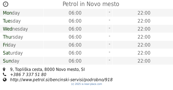
+386 7 309 93 70
website:
www.petrol.si
Latitude:
45.8420965
, Longitude:
15.216884
larger map & directions
read more
nearest Gas station
4.605 km
BS Novo mesto - Seidlova
Seidlova cesta 50, Novo mesto
Gas station
read more
4.606 km
Petrol
Seidlova cesta 50, Novo mesto
Gas station
read more
5.021 km
OMV BENCINSKI SERVIS
Levičnikova cesta 4
Gas station
read more
5.665 km
Petrol
Belokranjska cesta 3, Novo mesto
Gas station
read more
7.063 km
Petrol
Topliška cesta 9, Novo mesto
Gas station
read more
43.762 km
BS Celje - Ljubljanska
Ljubljanska cesta 38, Celje
Gas station
read more
43.929 km
BS Celje - Mariborska
Mariborska cesta 21, Celje
Gas station
read more
43.936 km
Petrol
Mariborska cesta 21, Celje
Gas station
read more
43.978 km
BS Celje - Kidričeva sever
Kidričeva ulica 21, Celje
Gas station
read more
44.053 km
OMV BENCINSKI SERVIS
Ljubljanska cesta 110, Celje
Gas station
read more
44.377 km
OMV BENCINSKI SERVIS
Mariborska cesta 84, Celje
Gas station
read more
44.397 km
OMW bencinska crpalka
Mariborska cesta 84, Celje
Gas station
read more
44.535 km
Petrol
Bežigrajska cesta 1, Celje
Gas station
read more
44.54 km
BS Celje - Interspar
Bežigrajska cesta 1, Celje
Gas station
read more
45.053 km
MOL
Mariborska cesta 111, Celje
Gas station
read more
45.295 km
Petrol
Mariborska cesta 121, Celje
Gas station
read more
46.655 km
OMV
Lopata 80, Celje
Gas station
read more
46.722 km
Petrol BS Lopata AC - sever (smer Ljubljana)
Lopata 81, Celje
Gas station
read more
46.722 km
BS Lopata Ac - sever
Lopata 81, Celje
Gas station
read more
48.379 km
Gas station Logo
Velika Pirešica 60, Žalec
Gas station
read more
📑
all categories
Accounting
Administrative area level 1
Administrative area level 2
Airport
Amusement park
Aquarium
Art gallery
Atm
Bakery
Bank
Bar
Beauty salon
Bicycle store
Book store
Bowling alley
Bus station
Cafe
Campground
Car dealer
Car rental
Car repair
Car wash
Casino
Cemetery
Church
City hall
Clothing store
Colloquial area
Convenience store
Country
Courthouse
Dentist
Department store
Doctor
Electrician
Electronics store
Embassy
Establishment
Finance
Fire station
Florist
Food
Funeral home
Furniture store
Gas station
General contractor
Grocery or supermarket
Gym
Hair care
Hardware store
Health
Home goods store
Hospital
Insurance agency
Jewelry store
Laundry
Lawyer
Library
Liquor store
Local government office
Locality
Locksmith
Lodging
Meal delivery
Meal takeaway
Mosque
Movie theater
Moving company
Museum
Natural feature
Neighborhood
Night club
Painter
Park
Parking
Pet store
Pharmacy
Physiotherapist
Plumber
Point of interest
Police
Post office
Premise
Real estate agency
Restaurant
Roofing contractor
Route
Rv park, camping
School
Shoe store
Shopping mall
Spa
Stadium
Storage
Store
Subpremise
Supermarket
Synagogue
Taxi stand
Train station
Transit station
Travel agency
University
Veterinary care
Zoo
administrative area level 3
sublocality level 1
↑